Satellite Maps Aid Tree Health Monitoring
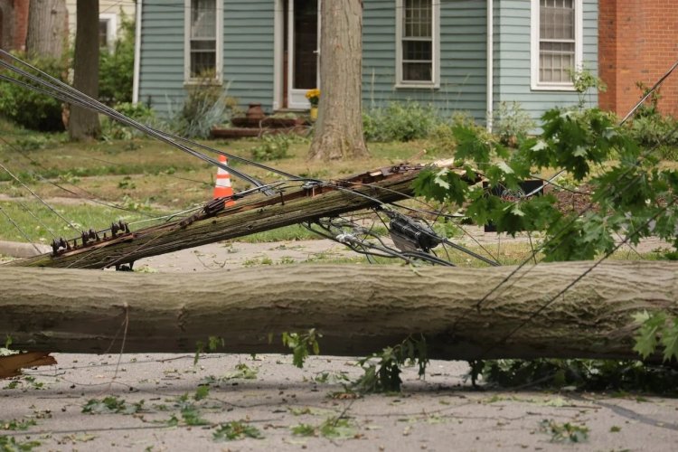
Chilean authorities have deployed satellite maps to monitor the health of the trees in Santiago after a massive tree fall following strong winds toppled power poles and knocked out electricity to thousands of homes in early August.
The Natural Resources Information Center in Chile uses satellite tracking to measure chlorophyll levels in trees and assess the vitality of vegetation and green areas. This monitoring aids in identifying areas potentially vulnerable to damage.
According to the system, areas appearing red on the maps indicate healthier vegetation compared to areas that are less red or brown.
Manager of natural resources information center of Chile, Noelia Tastets, said: "It shows us the reality of the state of chlorophyll in the trees. So, it allows us to see the state of the tree in terms of how much chlorophyll it has and gives us an indicator of the state of the vegetation. As it is reflected in red, it gives the human eye more clarity on how much chlorophyll a tree has or does not have. So, for example, here, the redder trees are in a better state than those we can see in this sector, which are less red or brown. So this means that this vegetation is perhaps in a drier state or not as vigorous as the redder ones might be."
In early August, strong winds in Santiago resulted in the fall of several trees and light poles, leaving over 700,000 residents without power. As of last week, electricity had still not been restored to 140,000 households, leading to protests across affected neighborhoods demanding the return of electricity services.
Chile's President Gabriel Boric has urged electricity distribution companies to expedite power restoration in the affected areas.